The Great Columbia River

Northwest Passage
William Dietrich
University of Washington Press 2016 edition
washington.edu/uwpress

A Few Excerpts
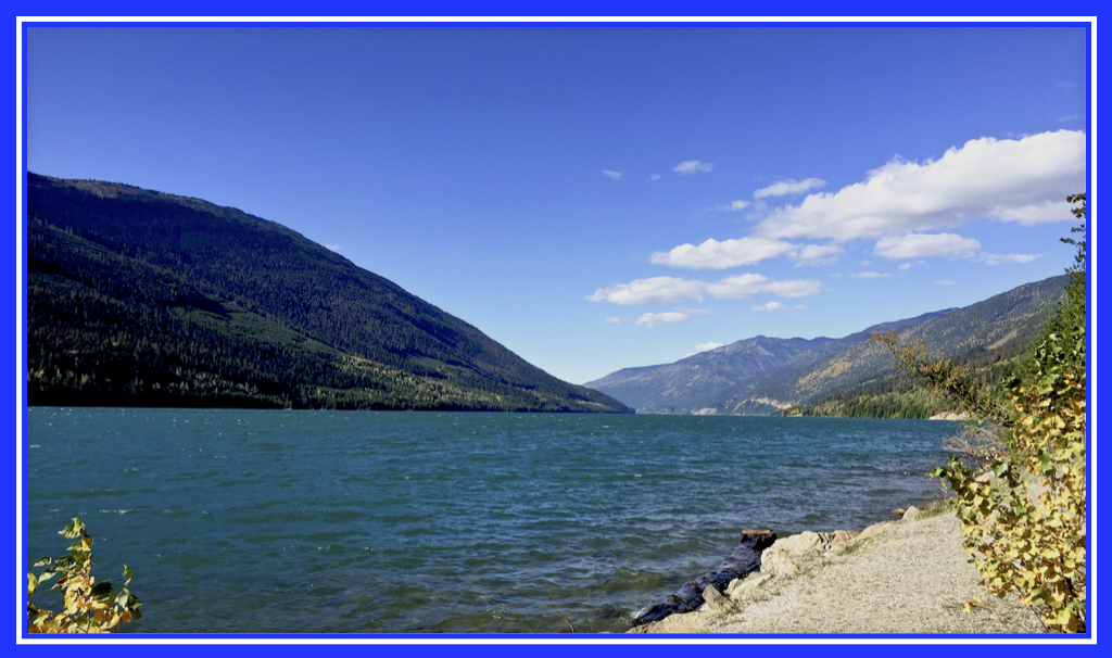
At its source, twelve hundred miles upriver in Canada, the Columbia is also confusingly broad—if one accepts as its source ten-mile-long, reed-fringed Columbia Lake, cupped between the Rocky and Purcell mountains. (The river issuing from the lake, however, is not broad at all: it forms a clear, merry, seventy-five-foot-wide scenic water hazard at the Fairmont Hot Springs golf course. But the point here is geographic similarities.) When lit by the sun the lake is breathtaking in the purity of its birth, a sapphire and emerald gem hugged between two mountain ranges cloaked with forest.
The Columbia's source is the location of one of the stranger relationships in the river's geography. It has a hesitant brush with the Kootenay River but won't marry that stream until the two rivers have completed a huge loop totaling eight hundred miles. Columbia Lake is separated from the Kootenay by that mile-and-a-half-wide patch of forest and meadow called Canal Flats that explorer David Thompson kept portaging across. The infant river drains out of the lake to the north and the Kootenay, at that point the larger river, runs south. At one time in prehistory the rivers were probably linked at Canal Flats, and the close pass of this sister river today sheds light on a question that arouses genial debate among Northwesterners: just what is the ultimate source of the Columbia River?

The entire idea of "sources" of rivers misrepresents their true nature as a hydrological loop, a cycle fed by evaporation from the sea and precipitation from the atmosphere. Still, it would unquestioningly be appealing to straddle a rivulet and know that it, and it alone, could claim to grow into the mighty Columbia. The source lake is too big and vague for some people's tastes, and a few have pointed to a boggy spring on the lake's southern shore as a more dramatically tiny birthplace. The seep's contribution is negligible, however, and one could just as strongly make a case for one or another of the creeks that pour into Columbia Lake, such as Lansdowne, Warspite, Marion, Sun, or Dutch. Unfortunately, there is no reason to choose one of these creeks over another. A popular but erroneous claim made to tourists is that the river rises in the Columbia Ice Field of Banff National Park. While the river and ice field may share a name, the glacial melt water actually enters the river one hundred and fifty miles downstream from Columbia Lake. Thus by default the lake is the source of general geographic consensus.
However, if one insists on a point south of Columbia Lake itself, then perhaps the ultimate source is the Kootenay River. Geologists believe ground water from the Kootenay almost certainly migrates through the gravel of Canal Flats to feed the northern end of Columbia Lake, and so the origin of one river is in part the borrowed flow of another. Why the two rivers are separated or joined at any one point in geologic history is due to deposits of Kootenay sediment that over a period of centuries or millennia marries and later divorces it from the sluggish Columbia. Thus we have here a river so broad at its mouth as to confuse Lewis and Clark, and so imprecise at its beginning as to defeat attempts to pinpoint an initial rivulet. A damned difficult stream.

The cradle of the Columbia is a surprisingly gentle place, however. The river will fall half a mile in its journey to the sea, but for its first one hundred miles it drops a leisurely fifty feet in a meandering course of sloughs, lakes, and marshes that resembles the bucolic lower river west of the Cascade foothills. Near its beginning and just before its end, the Columbia has a similar broad, lazy character.

Between these two points the river once roared down scores of rapids, but now it is as prim and controlled as an English butler as it steps down its staircase of dams. In the process the river crosses an international boundary, and the fact that it does so without breaking its mannered character is as remarkable as the engineering of its dams. Fifteen percent of the Columbia's watershed, 30 to 40 percent of its flow, and 38 percent of its length are in Canada. This required a river treaty of joint cooperation and development unprecedented in the world.
The river's long reach does create jurisdictional tangles, however. Once in the United States, the Columbia gathers water from Washington, Oregon, Idaho, Montana, and small corners of Wyoming and Nevada. The Columbia markets power as far as Texas and ships wheat from the Dakotas. Californians throwing switches on air conditioners can indirectly cause generators to hum at British Columbia's remote Mica Dam, and Canadians seining Columbia salmon off the coast of Vancouver Island start a ripple of trouble that results in water spillage from dams to help fish that can leave reservoir boat ramps dry near Orofino, Idaho.
Between beginning and end the Columbia gathers water from several dozen major tributary rivers, runs through fourteen huge dams, directly waters nearly a million acres of farmland, generates enough electricity to power a score of major cities, supports a dwindling but still significant fishery, and displays one of the most varied catalogues of scenery on the continent. It bursts through a Cascade mountain gorge so beautiful that some residents are still heartbroken it did not become a national park. The Columbia's terrain along different parts of its course mimics Switzerland, Germany, Italy, Nevada, Nebraska, and New Zealand. Taken as a whole, however, it has a geography unique to itself.

It can be a place of postcard perfection. The view in the eastern gorge around Sam Hill's lonely desert mansion at Maryhill, looking west down a brilliantly blue river toward the dark nest of forest surmounted by the icy egg of Mount Hood, is rousing in its magnificence. But the river also has quieter, subtler beauties that take you by surprise: the olive shadow of a salmon gliding through river murk behind a fish-counting window at McNary Dam, the surprisingly intricate natural garden of grass and flowers the desert can produce on the lonely shore of the Hanford nuclear reservation, the awe-inspiring sixty-story-high caramel-colored rock wall of Mica Dam, the stately silvery march of transmission towers across sagebrush desert, the startling red wink of a distant barn across an ocean of young green wheat, the crystal forest created by a treacherous ice storm near Cape Horn, the wide, solemn eyes of an Indian pictograph staring across the river at a passing Amtrak train.
The Columbia rises in this continent's Switzerland, that corner of steep glaciered mountains and achingly green valleys that is southeastern British Columbia. It gathers itself together in an emerald trench between the Rocky Mountains and the Columbia Mountains, the latter a block of rugged ranges that include the Purcells, the Selkirks, and the Monashees. The river is drip-fed from hundreds of glaciers (by official count, four hundred and twelve in the Selkirks alone) and makes a hairpin turn in Canada, wrapping around its namesake mountains to run back south again through narrow reservoirs and glacier-carved lakes toward the American border.
The Columbia is an important river not because of its twelve- hundred-mile length but because of its volume and fall. With its tributaries, it represents about 40 percent of the potential hydroelectric capacity of the United States. As it falls the Columbia digs, and while its rocky course keeps it from being a particularly silty river, before the dams it carried 7.5 million tons of sediment to the sea every year. One of the interesting features of the Columbia is the way its colors change like a mood ring as it comes down through the mountains, dropping sediment here and picking it up there: going from glacial milk to aqua, blue, green, browner with the addition of the muddier Snake, and finally a pewter in its lower stretches, opaque and reflective enough to take on the colors of the sky.

The Columbia is a developed river. What this means is that from Donald Station, British Columbia, to Bonneville Dam, near Portland, Oregon—a distance of about nine hundred miles—the Columbia for the most part is a series of computer-regulated hydroelectric pools, filling and falling to the rhythm of political storms as much as meteorological ones. Where possible, each reservoir backs up to the lip of the dam above it, ensuring there is no wasted energy in the river's long run. There are fourteen dams in all—Mica, Revelstoke, and Keenleyside in Canada; Grand Coulee, Chief Joseph, Wells, Rocky Reach, Rock Island, Wanapum. Priest Rapids, McNary, John Day, The Dalles, and Bonneville in the United States—dams so geometric and austere that they seem to hum along on their own like an alien space station.

The powerhouses tremble from the volume of water the Columbia can muster. Craig Sprankle, the Bureau of Reclamation spokesman at Grand Coulee Dam, took me down flights of concrete stairs into the basement of the dam's third powerhouse. We stepped into a dimly lit side corridor with a wet, musty smell far earthier than the faint technological odor of oil and ozone that pervaded the antiseptic main gallery above. Rusty water dribbled into a drain, and the concrete shaft ended in a short flight of stairs leading up to a white-painted steel wall. In the center of the wall was a thick bulkhead door fastened with fat, sweating bolts. We put our hands on the steel and felt its vibration. On the other side was the curving penstock feeding water to just one of Grand Coulee's turbines, energy enough behind just this one wall to light a city nearly the size of Seattle. "Each penstock," Sprankle told me, "carries more water than the entire Colorado River."
The dam highest on the Columbia River is Mica, arguably the most beautiful, surprising, and arrogant on the entire river. It seems as remote as a Guatemalan jungle ruin, rudely intrusive in the pyramidal solidity with which it backs up huge Kinbasket Reservoir: a lake so vast that the timber cleared from its bottom was enough for one hundred thousand homes. Mica is more than one hundred and twenty miles from the nearest town, Revelstoke, and a would-be visitor drives more than two hours up a wild mountain valley with only a few logging trucks and a chain of snow-capped peaks for company. The forested valley tightens and tightens and at last becomes a steep rock-walled canyon and still there is no dam, and then you turn a last corner and there it is: boulders stacked eight hundred feet high from bedrock, or more than six hundred feet above the river surface. This is the tallest earth-fill dam in North America. It is built in a canyon so narrow and absent of level ground that its powerhouse is built in a huge cave blasted out of Mica Mountain, like the secret headquarters of a villain in a James Bond movie. The elevator that rises seven hundred and fifty feet is the highest in Canada west of Toronto, in a location so remote the dam has its own underground sewage treatment plant. The engineering that goes into a structure like this seems fantastic. Excavation in winter was done under a vast tent to keep out the relentless snow. The truck that delivered key equipment had forty-two tires and a second driver at the rear to steer around the mountain curves. The generators were floated into place on a cushion of air.

A wooden stairway climbs the face of the dam like a zipper up its middle. Perspective is so impossible around such a colossal structure that I decided to climb the 1,057 stairs for a sense of scale. (They are numbered so workers can turn off at the correct level and enter access tunnels into the dam. Most big dams are honeycombed with passageways, penstocks, and shafts.) Climbing upward, I began to get a sense of the depth of the turquoise sea Mica holds back, measuring the human triumph of this plug with my own sweat. Panting at the top, I cooled in the chill breeze off a reservoir which curved far out of sight. So grand, so isolated, so indicative of the restless reach of modern technology. The dam is built on a fault fracture zone with a history of earthquakes and landslides. Accordingly, laser beams measure the precise distance between mountains, giving an alarm at the slightest sign of deformation and thus providing warning for possible evacuation downstreams. American engineers who have run what-if scenarios have determined that if Mica ever failed, every Columbia River dam downstream except the concrete monolith that is Grand Coulee would wash out. From Mica the river runs south through Canada in a thickly forested landscape, on past parks and pulp mills and the biggest smelter of its kind in the world, then south across the American border into the Okanogan pine hills. On it leads past Grand Coulee, out of the trees now and into an irrigated desert of orchards and vineyards backed by brooding desert cliffs. The Columbia has come to that great interior arid basin, the "Inland Empire" of dams and farms.
At Chief Joseph Dam, a bit more than half the distance from the Columbia's source to its mouth. Native American fishermen cast from a concrete causeway at the base of the dam and try to snag the few salmon that still mill in confusion here. Salmon once swam all the way to Columbia Lake, but first Grand Coulee and then this dam were built without fish ladders. That corked the runs from more than a thousand miles of spawning habitat. Dale Clark is a forty-six-year-old Colville Reservation Indian of Lakes ancestry from Canada who had quit his job at a fast-declining lumber mill to get a degree in public administration. While waiting for classes to start one September, he studied the water for salmon, something he has been periodically doing at this spot for twenty years. Wearing wraparound sunglasses to cut the water glare and an army camouflage jacket to ward off the coolness of the morning, he waited for the telltale shadow of confused fish, stumped by a fortress of concrete. Spotting their dark forms in the river below, he judged their true position by subtracting for the illusionary refraction of the water and hurled a treble-hooked line out beyond. Then he reeled across their backs. Migrating salmon swimming upriver don't feed and usually won't take a lure, so Clark has to snag them, play them to exhaustion, and then haul them up a thirty-foot concrete bulkhead with a gaff hook. On a good day he can catch half a dozen, giving many away to tribal elders. How long does he patiently study the water? "Pretty much all day," he said. "It took a few years to get the hang of it, how to snag them. I learned by watching."

Down, down steps the river, in desert country now, the old petroglyph sites mostly buried under water, the river stilled into obedient discipline. Below Priest Rapids Dam the river enjoys a rare free-flowing stretch and its most productive remaining salmon spawning area. The reason for this remnant natural flow, ironically, is the Hanford nuclear reservation. Here, where the plutonium for the world's first nuclear test at Alamogordo was produced, the hulking obsolete reactors that line the riverbank helped dissuade a start of the proposed Ben Franklin Dam because it would have backed up water over their radioactive remains. Hanford is arguably the single most polluted place in the Western world, but it is also so big, and has been kept free of people for so long, that it is one of the most important wildlife and ecological refuges left in eastern Washington.
Past Hanford the Columbia continues south to join with the Snake River and then bends west through a break in the Horse Heaven Hills called Wallula Gap, its southern bank now in Oregon. The country remains dry and sparsely settled along the pools of McNary and John Day dams, although the aridity is in part an illusion: drive to the top of the bluffs lining the river and you will find farms irrigated with free Columbia water pumped from the reservoirs, vegetables rolling across terrain where wild ponies once roamed.

Shortly before John Day Dam the land begins to rise around the Columbia as it enters the eastern Cascade Mountains. The man-made artifacts along the river become curious: seemingly isolated aluminum smelters, a replica of Stonehenge, the lonely mansion at Maryhill on a bluff so off the beaten track that the woman the mansion was named for refused to ever consider living there. The river enters the boundaries of the Columbia River Gorge National Scenic Area, and the land changes in one of the most sudden and dramatic transitions in the United States: from treeless and arid to forested and wet. Rainfall increases from fourteen inches a year at The Dalles to seventy-five inches at Cascade Locks, fifty miles downriver. Cliffs on the Oregon shore spout seventy waterfalls. On the Washington side the land is more sloping. Table Mountain sheared off near Bonneville Dam eight hundred years ago and slid into the river to create the six-mile-long Cascades of the Columbia, the roaring rapids that halted easy navigation just one hundred and fifty miles from the sea. Indian legend holds that it was not a mountain slope that slid to make the Cascades but a rock arch across the Columbia that broke in a war between jealous volcanoes: the Bridge of the Gods. A silver highway bridge built over the spot today has the same name.


The Gorge comes to a climactic end at the sheer cliffs of Cape Horn and the spectacular promontory of Crown Point. The river empties onto a green, rolling landscape of farm and forest and sprawling subdivision, threading past long sand islands of cottonwood and alder. There is a phallic monolith called Rooster Rock by the proper Oregon State Parks Department and Cock Rock by the pioneers. It is this gentle portion of the Columbia, crossing the trough between the Cascades and coast ranges, that passes Portland and the docks of neighboring Vancouver. The stockade of the reconstructed Hudson's Bay headquarters and the Northwest's oldest apple tree are just a mile from where Interstate 5 crosses the river. The Columbia swings north after that, looking for an opening in the coast range, and finally turns west at Longview for a final surge through the hills. The old fishing villages and mill towns on its tide-influenced final miles have names with a pleasant roll: Clatskanie, Skamokawa, Cathlamet, Altoona, Ilwaco. Then the last long bridge at Astoria, the Capes, the Pacific. Beginning and end.A trail leads up from Dead Man's Cove into the forest and over the neck of the cape to a Coast Guard station tucked onto a shelf behind the blunt rock, shielded from the pounding ocean. The station buildings are painted white and have red gabled roofs, exhibiting the trim military utility produced by government specifications. The place smells of salt water and mud and moist wetland. When the sun breaks through it is bright but teasingly heatless, its warmth sucked away by the moist air. The water stays a somber green-gray.


Our affinity for water is a part of our biology. We need to drink at least a quart of water a day because the chemistry of our bodies is based on water. It is a good solvent. A water molecule is shaped a bit like the head of Mickey Mouse, with two of the smallest and simplest atoms in nature, hydrogen, attached like ears to a larger atom of oxygen. The result is a simple molecule small enough to squeeze between bigger ones, fracturing their bonds with each other. Given time and energy, water can dissolve rock. While a water molecule as a whole is electrically neutral, there is a slight negative charge at the oxygen end balanced by a slight positive charge at the two hydrogen ears. This allows water to bond easily with other elements and compounds, forming solutions. If you want a medium that both breaks down matter and then transports the debris, water is ideal. It carries food energy to our cells and removes waste.
Accordingly, two-thirds of our weight is water and we carry a rough replica of the sea inside us. We are walking pink and brown canteens, liable with a false step to breach our skin and lose our ocean. We drink a ton of water a year. In fact, there is almost as much water stored in plants and animals as flows in the planet's rivers: a single Douglas fir tree can hold up to five thousand gallons of water, a human several pails full. Water has other interesting properties. It is ubiquitous. Hydrogen is the most abundant element in the universe. Some of the solar system's moons have volcanoes of erupting water that freeze like our own basalt, and the lava that boils out of the earth contains about 5 percent water. Volcanoes are the source of the vapor that eventually condensed in the atmosphere and rained out into the oceans. If rock can produce water, water carries rock. Rivers are mineral water. The ocean has 47 trillion tons of suspended minerals. and just the world's sixteen largest rivers pour in fifty-six additional tons every second. Only a small part of a river's erosive power comes from chemical dissolution of rock; most comes from the abrasion of transported sediment like liquid sandpaper. Precipitation and rivers wear down North America at an average rate of about a foot every ten thousand years. The Colorado carried enough silt before it was dammed to make a mound one hundred feet square and as high as a twenty-story building every day. The Missouri was so dirty that its steamboat boilers had to be cleaned of mud each evening. Rock in the Columbia Basin is relatively hard and its grinding is slower: Columbia River water has less than half the salts and minerals of the Mississippi and an eighth of the Colorado. Yet just since 1868, the river is estimated to have carried 400 million to 500 million cubic meters of sediment into its estuary. Today such erosion is trapped behind dams, slowly silting over former salmon spawning beds.
Rivers represent dissipated energy. Every day the sun evaporates as much water as is contained in all the world's rivers. Most of this rains back into the sea, but some is lifted and blows over the continents as rain and snow. The vast majority of this potential energy is wasted. Rivers can lose up to 97 percent of it from friction with their beds. Upstream paddlers learn to hug the banks where friction slows the current. The current a few millimeters off the bottom of a river is slower than the flow above, giving rock-dwelling insects and mollusks a relatively sheltered place from the howling hurricane of current overhead. Rivers also spend energy by carrying sediment, like a freight train consuming diesel fuel. When Hoover Dam's reservoir captured Colorado River sediment and the water pouring out of the powerhouse suddenly became relatively clean, it carried so much extra energy downstream that it rapidly sawed down through rock and sediment, leaving irrigation intakes below the dam high and dry.
By the late nineteenth century, the federal government decided to try to harness similar energies to fix the mouth of the Columbia. As the Coast Guard boat swings back toward shore I study the first evidence of the engineered river: the long black fingers of the Columbia jetties. When started in the late 1800s, these rock breakwaters were one of the largest and most difficult U.S. government building projects yet attempted. Their purpose was simple enough. It was not just that the river entrance was shallow and rough; it was also unpredictable. The vast river and tides shifted sand around like a fleet of bulldozers, assuring shipwrecks would lend their vessel's names to such features as Desdemona Shoals and Peacock Spit. (The Desde- mona was wrecked when Captain Francis Williams bet the price of a new Sunday suit he could get her inside the bar by New Year's Day, 1857, and didn't wait for a river pilot.) For pilots and captains approaching the Columbia, it was not just a question of keeping to the channel, but finding where it was. As a solution the Army Corps of Engineers proposed jetties. They would form twin walls jutting out into the ocean to stop the casual slop of sand north and south across the river entrance. Additionally, by squeezing the river's current at its mouth into a narrower passage, they would speed its flow. As a river collides with the ocean it tends to halt and dump its load of sediment, creating a hazardous bar. The fallout is a result of both the slower speed of the water and the tendency of the particles and salt in the sea to combine in a process known as flocculation, gaining weight and settling to the bottom. Accordingly, any restriction that sped the Columbia's punch into deeper water and concentrated the freshness of its waters would force the river to do the work of maintaining its own channel: properly constricted and directed, the Columbia was expected to clean itself.

Actually building the jetties became a formidable challenge. The initial $100,000 appropriated for the South Jetty in 1885 was eaten up by the first thousand feet across a tidewater bay. Its necessary width and depth were continually upgraded as winter storms washed or sucked under much of a summer's work. Engineers would ultimately determine that the jetty had to be seven miles long and required 8.2 million tons of stone. The cost eventually exceeded $10 million, a breathtaking sum at the time. To get rocks of a size large enough to resist battering by the waves, they had to be quarried upstream and barged down. It is illustrative of the different attitudes of the time that the Corps seriously considered blowing up eight-hundred-and-forty-eight- foot-high Beacon Rock, a spectacularly sheer monolith in the Columbia River Gorge a few miles below Bonneville Dam. Dynamite holes were drilled in the famous landmark and only the intervention of private investor Henry Biddle saved it from destruction. He bought the rock and then donated it to Washington State for a park. Other cliffs and quarries were dynamited, however. Down at the Columbia's mouth a new dock was built at the head of the jetty to unload the automobile-sized boulders by crane onto one of sixty-five waiting railroad dump cars. A railroad trestle was built atop the new jetty, extending on piers to jut over the water beyond the latest rock work. Five locomotives pulled the rock to where it could be dumped. The trestle pilings had to be pounded into deeper and deeper water as the jetty proceeded.

The Columbia and the ocean did not submit easily. "The difficulties that have beset the work accomplished during the past three years cannot be overstated," an officer of the Army Corps of Engineers complained in 1906. "Gale after gale has driven mountainous seas against the outer two miles of jetty and trestle, tumbling down the crest of a finished but too narrow section and carrying out at different times miles of the pile trestle over which the rock is conveyed. No language can adequately describe the fierceness of this onslaught. The place must be seen to be understood and appreciated. It is perhaps no exaggeration to say that there is no work in progress in the United States today at all comparable to this one in the difficulties, uncertainties, and dangers that arise at every stage of its construction." To cope with such forces, the jetty crest was widened from a planned ten feet to forty. When that proved inadequate, it was broadened to seventy feet in places to deal with the waves, and the height from the sea bottom to the crest grew taller than a five- story building. The base broadened to a width greater than a football field to gain stability. Most of the wooden trestle the tracks ran on was washed out in the winter of 1904 and had to be replaced. In 1906 another mile of track was destroyed in a storm. Not until 1936 when a massive concrete terminal was poured thirty-nine hundred feet from the jetty's seaward end did it finally stop disintegrating. Today the tracks have disappeared but the rock rampart remains as a ruled black line against the foggy softness of the landscape. Breakers frost them white, then pull back. The jetties' rigid defiance is our welcome to the Columbia, announcing that here you are entering something tamed.

William Dietrich
is a Pulitizer Prize-winning journalist


